What Your Best Paddocks Can Teach You
Every producer has paddocks they consider their best performers.
1 min read
 |
|
Imagine a super-smart assistant for your property, one that's learned from analysing millions of satellite images of land from all around the world, not just your local area or even just Australia. This new generation of AI, often called 'Foundation Models,' is like giving your satellite images a PhD. They don't merely assess how green your pasture is; they comprehend the land much more deeply by cleverly combining various types of information at once – like different satellite views (what we see, and even views that can see through clouds), detailed weather data, and the shape and slope of your land.
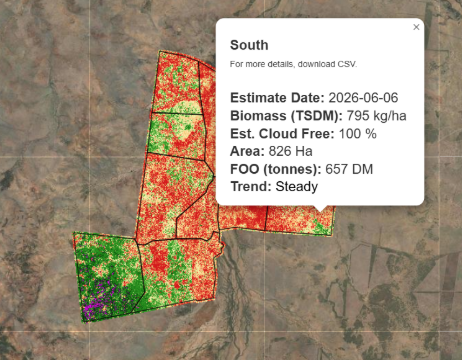
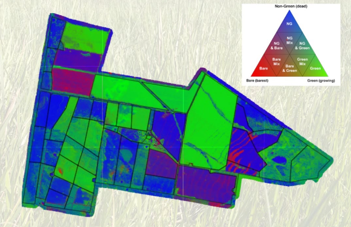
What does this mean for your rangelands? It signifies the potential for more accurate information than ever on the vital aspects you manage every day: how much feed you (actually) have available for your stock (forage availability), the actual condition of your soil and pastures (land condition), precisely how much ground cover is protecting your valuable soil, and broader insights into the health of the local environment (biodiversity indicators). Ultimately, it’s about getting a clearer, more complete, and more reliable picture of your property to help you make smarter, more confident decisions for your business and the long-term health of your land.
It’s all part of our ongoing commitment to continuously improve our services and ensure you have the most accurate, reliable, and practical insights to manage your rangelands more profitably and sustainably. We're genuinely excited about the potential to bring this next level of paddock intelligence to Australian agriculture.
Dr Peter Scarth
Stay tuned — more science updates from our team of scientists to come! |
Every producer has paddocks they consider their best performers.
We all know the importance of keeping an eye on pasture. But by the time a change is obvious from the ute window or during a paddock inspection, it...
When it comes to pasture management, it’s easy to focus on a single number.